INSTITUTE OF INFORMATION TECHNOLOGY
Nasa and Google have teamed up to create a virtual map to let you explore the red planet
November 07, 2018 | 04:22 / Interesting information
Google and Nasa have teamed up to create a version of Google Maps for our celestial neighbour, Mars.
Google Mars is a site which allows people to experience the red planet without the six-month, 140-million-mile (225-million-kilometre) journey. The map reveals the surface of the planet and signposts mountains, volcanoes, craters and spacecrafts.
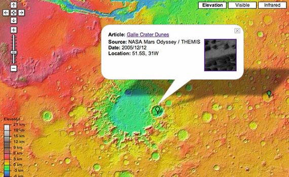
Nasa satellite data has been compiled by Arizona State University researchers and is one of the most accurate maps of the planet’s surface ever created.
Three views reveal our planetary neighbour in great detail, with the elevation map showcasing the planet’s topography, the visible map giving the highest resolution view and an infrared map showing the planet’s varying heat signature.
The interactive map is used in a similar way to Google Maps and allows people to scroll, zoom and select different places. Google Earth Pro lets users visit Mars too with another incredibly detailed map that reveals the planet’s surface in 3D.
The virtual trip to the planet will be easier and not as harsh on the body as a physical venture. Recent research has found that deep space travel could leave astronauts terminally ill.